Monday, April 30, 2018

4th POST - MITCHELL, SD


Friday 4/27, we left Big Lake, MO headed farther north.  We took I-29 N, crossed into 
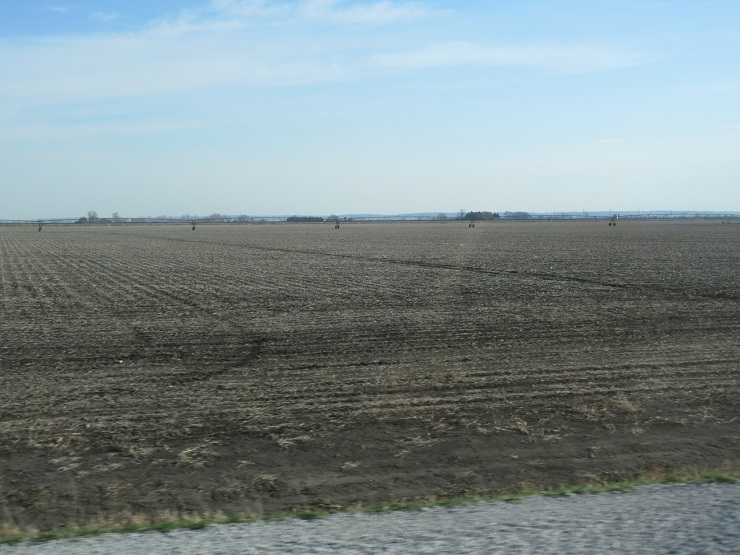
Iowa, and went through Council Bluffs to Missouri Valley.  Lots of flat farm country for miles & miles.  We’re getting into corn country, but it is too early for planting – do see some plowing all along.


At Missouri Valley, we took Hwy 30 west and made it to Wilson Island State Recreation Area.  The road out to this park is also through flat farm lands.


This is another campground we have been to a couple of times in past years, but it has really changed.  It also got flooded really bad in the big Missouri River flood of 2011 and was closed for several years.  They have done a lot of renovations, added some extra campsites, and enhanced the electric hookups (previously 30 amps, now all 50 amps).  The campground was almost full over the weekend, but by the time I took this picture Sunday afternoon, it was almost empty.


This park is right on the Missouri River, and next door to the DeSoto National Wildlife Refuge.


Part of the NWR is DeSoto Lake.  This is what is called an “oxbow lake” because many, many years ago the Missouri River had a huge bend and during one of the floods, the river channel took a short cut across the bend, cut a new channel, and left the big bend cut off from the river leaving the lake that’s here today.  This phenomena has occurred in several other spots on the Missouri River over the years leaving these ‘oxbow’ lakes – Big Lake that we just left is one of them. You can see from the pictures that the lake is about the same width as the river.


DeSoto NWR, like most NWR’s, has an auto tour loop – this one about 8 miles.  It partly follows the lake, but also goes through some wooded areas, past some huge grassland fields, and by some swampland and ponds.  We took the auto tour on Friday afternoon and then a couple of times on Saturday.


They must have some pretty powerful storms and tornados come through here from time to time.  We saw this twisted and broken Cottonwood tree that had suffered the consequences.


Also, we didn’t find out why, but there is lots of dead standing timber – mostly Cottonwoods.  We were wondering if somehow the big flood had something to do with it.


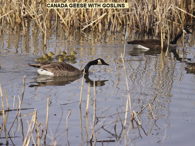
We didn’t see very many new birds – there was a Spotted Sandpiper by the road and we saw a pair of Bald Eagles on their nest across the lake.


Yesterday (Sunday) we went into Missouri Valley and attended worship service at the Missouri Valley Christian Church.  It was a contemporary type service and was OK, but not the kind of service we’re used to.  Of course, it was geared more toward the youth and there were a lot of young people there – that was great.

Today (Monday 4/30) we got back on I-29 and headed north to Sioux City, IA.  All along, there’s more of the same huge flat fields.


At Sioux City, we crossed into South Dakota, followed I-29 to Sioux Falls, SD, and took I-90 West. Almost got run over by a train!


Lots & lots of wide open spaces in South Dakota!


Today’s drive was mixed from a wind standpoint.  All day there was a 25-30 mph wind out of the South. For the drive up I-29 North it was a tailwind, so it didn’t affect the driving.  However, when we hit I-90 West it became a cross wind and that made it very hard to stay in a straight line.  Big trucks passing didn’t help a whole lot. Thank goodness it was only 65 miles to Mitchell, SD where we stopped for the night.

Question for all you physics majors – what effect does a 25-mph tailwind have when you’re driving 60-mph??

I was going to make this blog post yesterday, but because of very weak internet service at Wilson Island, I couldn’t do it. So here it comes today from Mitchell, SD – you get a day extra for no charge.  Tomorrow we’re headed on across South Dakota to Custer State Park. Later -----------


Friday, April 27, 2018

3rd POST - BIG LAKE, MO


Tuesday, we left Arrow Rock headed farther northwest.  We took I-70 west to Kansas City, took the I-435 bypass around, and then I-29 north through St. Joseph.  It was a very nice 200-mile ride to Big Lake State Park located about 11 miles west of I-29 and near Mound City.  We’re still in Missouri, but up in the far northwest corner.  We didn’t have reservations, but the park was almost empty.  Truly amazing – this is a really nice campground with over 100 sites and there was only one other camper here.


Interesting story – the last time we were here was in 2014.  The campground is right next to the lake and in 2011 it had flooded big time.  It was closed for 3 years!  In 2014, we were camped about 100 miles south of here and heard they were opening back up the next day.  We made a bee-line up here and were some of the first campers to use it after the flood.  At that time, they had done a lot of work, but none of the sites had any grass and were pretty muddy.  Now after 4 more years, they have it back in tip-top shape.

After we got set up, we sat outside awhile, but it started getting windy so we came in. The wind got stronger & stronger – somewhere around 20-25 miles per hour with even stronger gusts.  We were watching the Braves and all of a sudden, we lost it – looked out and the wind had blown over the satellite dish and broke it!  Thank goodness the wind died down during the night, but by morning it was raining.


Wednesday was a rainy day until middle of the afternoon – good time to bring in the satellite dish and get it fixed.  Later we drove about 10 miles back east toward I-29 to the Loess Bluffs National Wildlife Refuge. Previously, it was the Squaw Creek NWR, but someone complained about the word ‘Squaw’, so the government in their infinite wisdom changed the name in January 2017.  Uuuggghhh!

The refuge has an 11-mile auto loop that goes around the whole thing with a side road about 3 miles out the back entrance.  There are lots of marsh lands and ponds with all kinds of birds – tons of migrating water fowl.


Never can tell what you might see – this giant mud turtle was in the middle of the road!!


Of course, the birds are the main draw and we saw lots of them. 


Yesterday (Thursday) we were up early, took our 2nd cup of coffee with us and went back to the NWR.  A little chillier than Wednesday, but it was a beautiful sunny day!  We made the loop around – it takes 2-3 hours depending on how slow you go and how many stops you make – and then drove out to the truck stop at I-29 for breakfast.  After breakfast, we were back to the NWR for the 2nd loop of the day.  On the back side of the refuge is an exit which takes you to Mound City.  We took that little detour for a couple of grocery needs.  Back into the refuge, we finished the 2nd loop and headed back to camp.  All in all, a great day – saw lots more critters and birds.


After 3 days here, it’s time once again to move on up the road. Today (Friday) we are headed about 100 miles up I-29 to Wilson Island State Recreation Area near Missouri Valley, IA.  Yes, we’ll finally be out of Missouri and into Iowa.  There’s another National Wildlife Refuge there that we are looking forward to visiting. Until Next time ------


Monday, April 23, 2018

2ND POST - ARROW ROCK, MO


Thursday, we left Reelfoot Lake State Park and headed across Missouri. For those of you who are following along with Rand McNally, we came back south to Dyersburg, TN and hit I-155 west which took us across the Mississippi River into the Bootheel of Missouri and I-55 north.


At Sikeston, we took Hwy 60 west and followed it for 187 miles across the lower tier of Missouri to Mansfield.  The route was varied – lots and lots of flat wheat fields for a while, then into the hill country through unpopulated forests, then back into lots of hilly farm lands with cattle and pastures. The highway was a very good 4-lane all the way through the towns of Dexter, Poplar Bluff, Winona, Willow Springs, and Cabool.

At Mansfield, we took Hwy 5 north 54 miles to Lebanon.  This was a very curvy & hilly narrow little 2-lane highway – white knuckles when meeting big trucks. At Lebanon we went west 12 miles to Bennett Spring State Park and got a very nice campsite for the night.  All total, 356 miles – a long day!


Friday, we continued the journey.  We took Hwy 5 north again and was thankful that from Lebanon northward it was mostly 3 lanes and was a good ride.  However, at Camdenton we missed the turn for Hwy 54 and wound up going over some more hilly curvy roads in the area of the Lake of the Ozarks before we finally made it to Hwy 54.  Even had a toll bridge across the lake - $4.50 YIKES.

Once we were on Hwy 54, we made it to Jefferson City around 11:00 AM and decided to check out the Missouri State Capitol.  We found a big parking lot by a defunct bowling alley, parked the motorhome, unhitched the Jeep, and rode into downtown Jefferson City.  The capitol is an old and beautiful building and was under renovation.


After our sideline tour, we hitched back up, made it to Columbus, MO, and hit I-70 west – crossed the Missouri River, just one of several times we’ll see it.


Just past Boonville, we took Hwy 41 north to our destination for 4 days – Arrow Rock.  Hwy 41 is another narrow 2-lane, but at least it’s not as curvy as some of the others we were on. However, there are a couple of narrow bridges and you have to make sure there’s nothing coming so you can take it down the middle.


We arrived at the Arrow Rock campground and got set up in the site we had previously reserved.  Got birdfeeders out, some seed on the ground, and the birds started showing up –American Goldfinches, a few Chickadees, Titmice, House Finches, and a couple of Cardinals.  Put it out – they will come!


We won’t dwell on the historical town of Arrow Rock this time – this makes about four times we’ve been here and the history of the town has been documented in previous blogs.  Suffice to say it is a quaint little town that was on the route of all the explorers, pilgrims, and homesteaders headed west back in the 1800’s.  It has been designated as a State Historical Site and does draw a lot of visitors.


Saturday was a day spent doing one of our favorite things – riding the backroads!  There’s no traffic to speak of, so we can creep along looking for birds on the fences and power lines and sightseeing along all the farms and fields.  All the roads are named with letters which we find interesting.


The roads are very narrow and mostly very hilly – but again, we go slow and there’s hardly any traffic.  If we see an interesting sight or a bird we want to check out, we can just stop in the road.


We do see a lot of interesting things – from old churches to barns with ‘barn quilts’ on them, fields covered in “Henbit” (a really pretty purple wildflower), and a lot of spring newborns!


Sunday was a day of worship and rest.  We went into Marshall (about 20 miles) and attended a very nice worship service at the 1st Baptist Church.  Afterward we went to lunch at Bloomfield’s Family Restaurant, stopped in at Walmart for a few needed items, then made it back to camp for an afternoon of R&R.

Today, Monday, we got up a little earlier and took off on the backroads again hoping that we’d see more birds & animals earlier in the morning.  However, it was about the same – most of the same small birds on the fences & powerlines -  sparrows, finches, cardinals & doves. Did see a couple of hawks, but they were too far away to identify.  After riding about a 20-mile loop, we stopped in the small store/grill in Hardeman for breakfast.  This is big deer hunting country and the store had a great display of trophy mounts around on the walls.


On the way back to camp we passed a house with a pond with a lot of Canada Geese.  Some of the geese were enjoying the green grass in the front yard.


We’ve been here since Friday and now it’s time to move on again.  Tomorrow morning we’ll be heading out – on across Missouri to Kansas City, then north on I-29 to Big Lake State Park. Until next time --------